Chongqing South Bank photo route: old streets to night skyline
Chongqing's South Bank gives you four different city photographs without crossing the river: a green hillside old street, a layered neighbourhood, a blue-hour skyline and a broad night view toward Chaotianmen. Use the main Chongqing city guide to choose your trip length and neighbourhood base; use this page to execute one photography-focused afternoon and evening. The useful route is not a collection of viral pins. It is a sequence timed around the light:
- Longmenhao Old Street in daylight and early golden hour;
- Xiahaoli as warm light fades into blue hour;
- Nanbin Road Clock Tower for the first illuminated skyline frames;
- Changjiahui after dark for river, towers and the Chaotianmen confluence.
Begin about three hours before local sunset. The core route takes roughly four to five hours when you allow time to explore, wait for clean frames and eat or rest. It is approximately 3.1 km of walking between the mapped anchors, but that number hides steps and level changes inside the old streets. A taxi or live public-transport check between Xiahaoli and the Clock Tower makes the route much easier in heat, rain or low visibility.
This is a public-space route. It does not depend on entering a hotel, school, apartment corridor, rooftop or cafe terrace. Commercial tenants and internal passages change; follow current signs and keep the mapped street-level exits as your anchors.
The route at a glance
Two to three hours before sunset: Longmenhao
Start at Shangxin Street metro station, then walk about 400 metres to Longmenhao Old Street. Allow 60–75 minutes. Make the wider old-street frames first while the roofs, stairways and vegetation still hold detail.
About 90 minutes before sunset: Xiahaoli
Walk about 300 metres to Xiahaoli. Allow 45–60 minutes. Photograph the change in height, the street openings and the old-and-new city layers. Leave before full darkness unless the narrow lanes themselves are your main subject.
Sunset to early blue hour: move toward Nanbin Road
The walk from Xiahaoli to Nanbin Road Clock Tower is about 1.6 km and 22 minutes before stops. Walk it only when the weather, pavement and your energy make sense. Otherwise use a taxi or check live bus directions. Protect the blue-hour window instead of spending it proving that you can walk every metre.
Blue hour: Nanbin Road Clock Tower
Use Nanbin Road Clock Tower (南滨路钟楼) as an area anchor. Allow 30–45 minutes for the skyline to balance with the remaining sky. The pin is not a promised viewing platform; barriers, traffic controls and riverside works may move the safest camera line.
After dark: Changjiahui
Continue about 800 metres to Changjiahui Shopping Park. Allow 60–90 minutes for the riverfront, Danzishi-side streets, food and the final skyline. Finish here instead of trying to reverse the entire walk after dark.
Why this direction works
The route moves from small foreground detail to large skyline. In daylight, Longmenhao and Xiahaoli offer stone, timber, trees, roofs and people-sized streets. After sunset, those details become harder to separate, while the riverfront becomes stronger as the towers light up. Walking in the opposite direction spends the best daylight on open water and reaches the old streets when their surfaces have disappeared into shadow.
It also reduces unnecessary climbing. You still encounter stairs and slopes, but the day is organised around a downstream riverside finish rather than repeated returns to the hill. If you need a mostly level evening, begin directly at the Clock Tower and continue to Changjiahui; you will lose the old-street section but preserve the two strongest night locations.
Stop 1: Longmenhao in daylight and golden hour
Longmenhao Old Street sits on a steep green slope facing the Yuzhong peninsula. Its best photographs explain the site in layers: foliage or masonry in front, old buildings and stairs in the middle, then bridge or skyline beyond. A tight portrait beside one wall may look attractive, but it does not show why this part of Chongqing is distinctive.
Use the public lanes to find three kinds of frame:
- The hillside overview: use a phone's 1× camera or roughly 24–35mm. Keep several roof levels and a staircase in view. Wait for one or two people to provide scale instead of trying to empty the scene.
- The framed city: look through an open arch, terrace edge or gap between buildings toward Dongshuimen Bridge or Yuzhong. Expose for the bright distance and let the near wall become a darker natural frame.
- The climbing street: stand to the side of a wide public landing and photograph along the steps. Keep the phone level so the buildings do not lean. A companion should pause where other visitors can still pass.
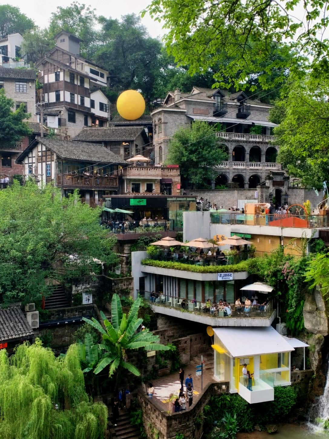
This documentary view shows the useful visual structure. The plants create a near layer, the stacked buildings explain the slope, and people make the height readable. For your own frame, simplify the commercial signs and temporary decorations by moving a few steps rather than zooming tightly into one facade.
Arrive early enough to explore without guarding one viral angle. The most popular openings can collect a queue, and a lens that is slightly wider or a viewpoint one landing away often produces a cleaner photograph. Do not enter a cafe, restaurant or private terrace merely because an old post shows the view from there. Ask staff before photographing from any business interior.
Target result: an old hillside neighbourhood that visibly belongs to a vertical modern city.
Stop 2: Xiahaoli as the light changes
Xiahaoli is close to Longmenhao on the map, but its role in the route is different. Longmenhao gives the broad establishing view. Xiahaoli is better for a more intimate sequence: a bend in a lane, a stair disappearing between walls, a distant bridge through a narrow opening, and then a final outward view as the city lights begin.
Use the public Xiahaoli pin to keep your route anchored. Inside the area, follow signed public passages. Do not use a school gate, residential doorway, hotel landing or bookstore interior as a required waypoint; access and operating arrangements can change even when an old photo remains online.
Make four short sequences rather than one long portrait session:
- Street entrance: photograph the lane before it becomes crowded. A 24–35mm field of view should retain the wall, slope and destination of the street.
- Turn on the steps: place your subject on a wide landing, then photograph from above or below so the railing draws a diagonal through the frame. Leave the centre open for pedestrians.
- Old-to-new compression: when a tower or bridge appears beyond the old buildings, switch to 2× on a phone or 50–85mm on a camera. The longer view makes the two periods of the city appear closer together.
- Blue-hour exit: make one final frame with a cool sky and the first warm lights. Then leave for the open riverfront before the sky becomes black.
For a person-in-frame result, use movement that belongs to the location: climbing a step, turning at a landing, or looking through an opening. A large artificial pose in the middle of a narrow lane blocks circulation and usually hides the architecture that made the place worth visiting.
Target result: a short visual story that moves from enclosed hillside streets to the illuminated city beyond.
Optional earlier start: Open Port Heritage Park
If you can begin about four hours before sunset, start at Chongqing Open Port Heritage Park. From its map anchor, Longmenhao is roughly 600 metres or nine minutes on the planned walking route. Treat the park as an earlier starting block, not as a detour after you have already reached Xiahaoli.
The park adds a more open architectural foreground and a long-lens relationship with Dongshuimen Bridge and the opposite-bank towers. Use 50–100mm to simplify the scene. Keep the bridge clear of your subject's head and leave enough road or river context to explain the scale.
Check current signs when you arrive. City-renewal areas can contain operating venues, temporary event zones and changing construction boundaries. The page's core route still works if the park is partially inaccessible: go directly to Longmenhao from Shangxin Street metro.
The critical transfer: Xiahaoli to the Clock Tower
This is where an attractive online route can become a frustrating real one. AMap estimates about 1.6 km and 22 minutes on foot from Xiahaoli to the Clock Tower, before photo stops, crossings or a wrong level. In mild weather, the walk provides useful riverfront transitions. In summer heat, heavy rain or haze, it can consume the most valuable light and leave you tired before the skyline appears.
Choose deliberately:
- Walk if the pavement is dry, you have at least 35 minutes before sunset and the riverfront itself is part of your story.
- Use a taxi or live bus directions if you are late, carrying a tripod, travelling with children, protecting makeup or clothing, or avoiding steps and humidity.
- Skip the Clock Tower and go directly to Changjiahui if only one night panorama matters. Do not turn the guide into a checklist at the expense of good light.
Save the English–Chinese pairs Nanbin Road Clock Tower (南滨路钟楼) and Changjiahui Shopping Park (长嘉汇购物公园). They reduce confusion when a driver or map result offers several points along the long Nanbin Road corridor.
Stop 3: Nanbin Road at blue hour
The Clock Tower is useful because it gives the route a stable public area anchor close to the river. It is not the only possible camera position, and it is not an invitation to stand in a traffic lane. Follow the current promenade, crossing and barrier layout, then move within the open pedestrian area until towers separate cleanly behind the road or river edge.
Blue hour often lasts less than the time a crowded route makes you think. Use this order:
- Wide establishing frame: 24–35mm, with a visible river or promenade edge and enough sky to retain colour.
- Compressed skyline: 50–85mm, aligning the brighter towers without losing the base of the city.
- Person and skyline: place the subject several metres from the camera so the face and buildings can both remain readable. Use a small amount of light from a phone or pocket LED only when it does not disturb others.
- Reflection or traffic experiment: try it only after the clean frames are secure. Wet pavement can be attractive, but rain also brings glare, spray and slippery surfaces.
Slightly underexpose to preserve illuminated signs and windows. On a phone, tap a bright building and drag the exposure down until the highlights show detail. On a camera, start around f/4–f/5.6, raise ISO only as needed, and keep a shutter speed that matches your subject: faster for people, slower only for a supported cityscape.
This area is also associated with commercial motorcycle videos. If you want that finished product, read the separate Chongqing motorcycle night-photoshoot guide and use a booked operator's exact live meeting pin. The Clock Tower pin is an area reference, not a guarantee that a motorcycle team meets there.
Target result: a recognisable skyline balanced against a blue sky, with the South Bank foreground proving where the photograph was made.
Stop 4: Changjiahui after dark
Walk about 800 metres, roughly 12 minutes before stops, from the Clock Tower to Changjiahui. The final section opens toward the meeting of the rivers and the Chaotianmen skyline. It is where a longer lens becomes most useful.
Start with the public riverfront and make a clean skyline before searching for foreground decoration. The distinctive towers of Raffles City Chongqing can dominate the frame; include water and neighbouring buildings so the result remains a cityscape rather than an isolated building study.
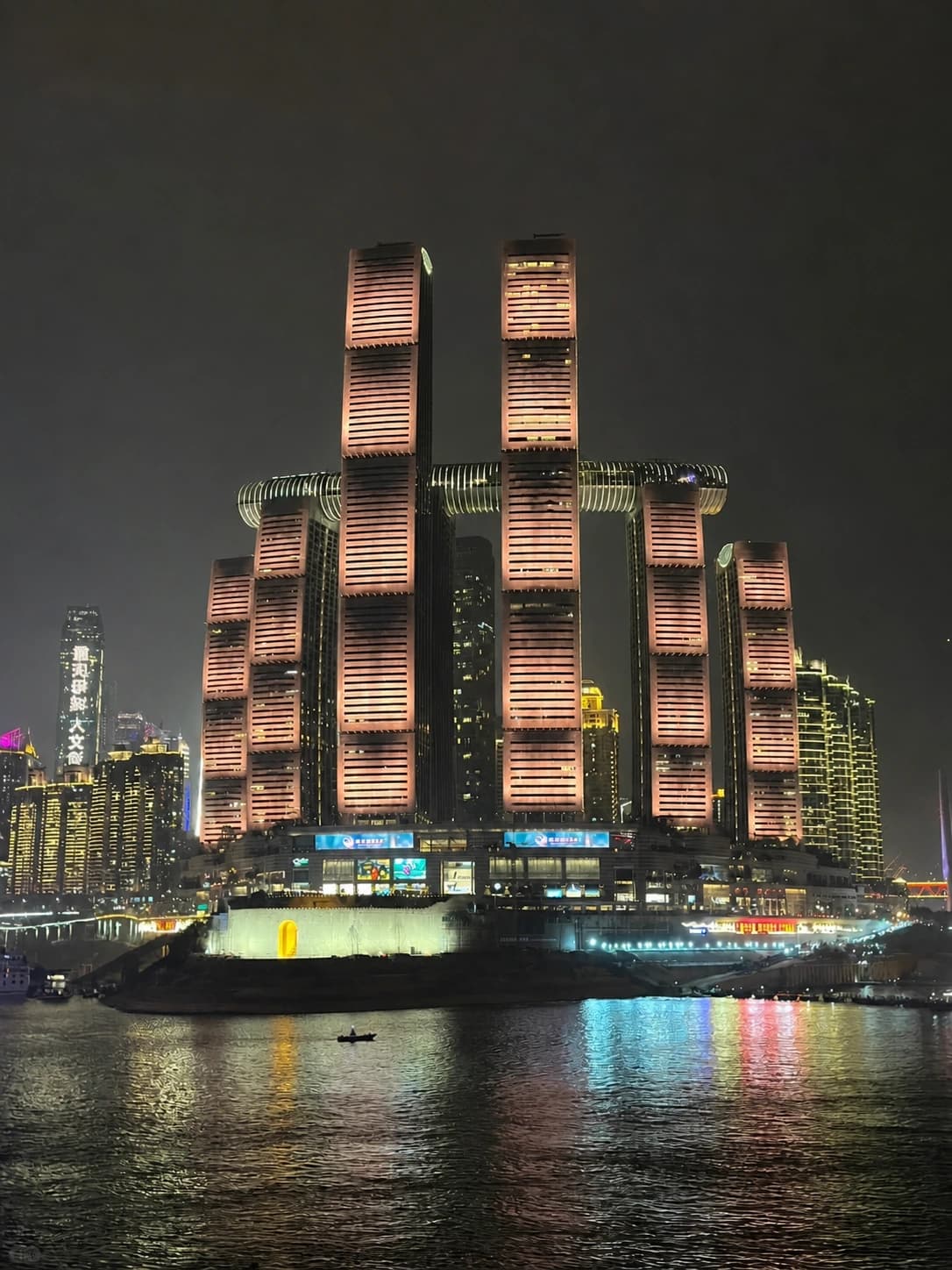
This night view demonstrates the final route's visual goal: water as a dark lower layer, reflected light in the middle and a clearly separated tower group above. A vertical frame suits the height of Raffles City; make a horizontal version as well if you want more river and neighbouring skyline.
Use 50–85mm for a balanced skyline and 85–135mm for a tighter tower compression. Long lenses exaggerate haze and camera shake, so brace your elbows or use a small tripod only where its legs do not narrow the promenade. Protect the brightest tower panels by reducing exposure. Lifting a slightly dark river later is easier than recovering clipped building lights.
Changjiahui is also the logical place to pause for food or call a taxi. Choose an open business when you arrive rather than building the route around one restaurant's current opening hours. If you intend to stay for a late river view, check your live metro or taxi plan before settling in.
Target result: a complete night sequence with water, reflections and the Chaotianmen tower group, rather than another close old-street photograph after the useful ambient light has gone.
If a drone show is scheduled
Do not assume there is a show because a recent video contains one. Chongqing drone performances depend on officially announced dates, weather, airspace control and crowd arrangements. Check the maintained Chongqing drone-show schedule for the date of your visit. If the date remains unannounced, plan this route as an ordinary skyline evening.
On a confirmed show night, simplify the route. Reach your chosen viewing area early and avoid a last-minute river crossing. Barriers, station controls and traffic can alter the normal walking line. Use a wide frame that includes a recognisable skyline beneath the drones, then keep watching rather than moving through a crowd for several nearly identical angles.
Full-day version: Huangjueya and Huangge Ancient Road
Strong visitor routes often add Huangjueya Old Street and Huangge Ancient Road. They are worthwhile for stone trail, trees and older hillside texture, but they should be a separate morning block, not extra pins squeezed into the four-hour photo route.
A practical full day is:
- visit Huangjueya in the morning;
- walk only the signed portion of Huangge Ancient Road that matches your footwear and weather;
- stop for lunch and a proper rest;
- transfer separately to Shangxin Street metro;
- begin the core Longmenhao-to-Changjiahui route three hours before sunset.
Do not assume a social-media line represents one continuous, signed trail all the way to the evening route. Navigation can place you on the wrong elevation, and wet stone becomes slippery. Wear shoes with grip, carry water and turn back when an unsigned branch does not match the live map.
Easier, rainy and low-visibility versions
Easier evening
Take a taxi to Longmenhao, explore only the broadest public lanes, then take another taxi to Changjiahui. This preserves an old-street result and a night skyline while removing the long riverfront walk. It is the better option for limited mobility, a heavy camera bag or formal clothing.
Rainy evening
Skip steep stone stairs when they are slick. Use sheltered public edges at Longmenhao only while they remain safely open, then move to a managed indoor break near Changjiahui. Reflections can improve a night photograph, but no image requires standing beside moving traffic or extending a tripod into the walking path.
Hazy evening
Prioritise Longmenhao and Xiahaoli, where the subject is close. At the river, use a shorter focal length and include more foreground. A long telephoto view through haze will flatten contrast and can make the landmark disappear. If the skyline is the main purpose of the day, use a weather app's visibility reading and be willing to move the route to another evening.
Peak-crowd evening
Make one frame at each stop and keep moving. The route works because each location has a different visual job; you do not need ten variations from the busiest opening. If a queue forms at a narrow passage, photograph the wider street structure instead of using the passage as a portrait studio.
Phone and camera setup
A phone with 1× and 2× cameras can complete the whole route. Use 1× for old-street context and 2× for the skyline appearing between buildings. Reserve 0.5× for genuinely tight spaces; it stretches faces and tilts edge buildings when used carelessly.
For a camera, a 24–70mm zoom covers most work. Add a 70–200mm only when compressed skyline images are a main goal. Carry less rather than losing the route to lens changes and a heavy bag.
Before leaving the metro:
- clean every phone lens;
- set the camera to record RAW only if you already know how you will process it;
- keep a small power bank and cable accessible;
- download or save the AMap pins;
- bring a cloth for rain and river mist;
- avoid a full-size tripod on crowded evenings;
- keep passport, wallet and phone in a closed front or cross-body bag.
At night, take a normal exposed frame and a slightly darker one. Chongqing's brightest signs often look fine on a small screen but lose detail when enlarged. A darker file with intact lights is the safer edit.
Public-space and portrait etiquette
Longmenhao and Xiahaoli are visitor areas connected to lived neighbourhoods and operating businesses. Keep doorways, stairs and fire routes open. Ask before using furniture or photographing inside a business. Avoid treating residents, workers or children as background props for a close portrait.
At the riverfront, stay behind barriers and use marked crossings. A camera position seen in an old video may now be affected by traffic management, construction or an event. Current signs override this guide. Do not attach a clamp or tripod to public railings, fly a drone without checking the current rules, or use a bright light toward traffic and vessels.
Final route checklist
- Check the day's sunset and start at Longmenhao about three hours before it.
- Save the five AMap anchors and their Chinese names before leaving Wi-Fi.
- Give Longmenhao the daylight; give Xiahaoli the transition; give the riverfront the blue and night light.
- Decide at Xiahaoli whether the 1.6 km walk protects or wastes your blue hour.
- Photograph one clean wide frame before portraits, reflections or motion effects.
- Use public lanes and terraces; do not depend on a hotel, school, apartment or cafe interior.
- Treat the Clock Tower as an area anchor, not a guaranteed platform or commercial meeting point.
- Check the separate schedule before planning around a drone show.
- Finish at Changjiahui and confirm live transport before a late meal or long exposure.
This route is narrower than the broader eight-point Chongqing photo guide: it gives up citywide variety in exchange for one continuous South Bank story. Use the citywide guide when you want Liziba, Hongya Cave and the Grand Theatre; use this route when you want to follow the light from old hillside streets to a complete night skyline.
To place it inside a first visit, use the terrain-smart three-day Chongqing itinerary as the trip framework and replace its shorter Longmenhao stop with this complete afternoon-to-night route. The four-day itinerary already pairs Longmenhao with Nanbin Road, while the five-day itinerary includes Changjiahui; use this guide when photography matters more than completing every stop in those days.