Chongqing Eling to Liziba sunset walk
This short west-Yuzhong walk gives you a complete Chongqing sequence in one evening: a green ridge garden, a converted printing complex, ordinary hillside streets and a monorail entering a residential tower near the Jialing River. The useful direction is Eling to Liziba. It follows the city's levels downward and finishes at Line 2, while the reverse direction turns the same compact outing into a sustained climb.
The checked public route is:
Eling Station Exit 1 → Eling Park → TestBed 2 → Third-Level Road → Liziba monorail viewing platform
AMap gives the four walking legs a combined baseline of about 2.1 km / 29 minutes without stops. Allow 2.5–3.5 hours for the park, photographs, road crossings and the changing light. Start 2.5–3 hours before the local sunset on your date. That schedule keeps Eling Park and TestBed 2 in usable daylight, puts the quieter hillside road in warm late light, and reaches Liziba around sunset or early blue hour.
Calling this an “all-downhill” route is helpful only as a direction choice. It descends overall from the Eling ridge toward the river, but Chongqing still inserts short ramps, steps, uneven paving, curb changes and confusing levels. Wear shoes with grip and keep live walking navigation open.
Quick verdict
Choose this walk when you want one compact route with several visual moods, can manage stairs and slopes, and prefer public streets to paid observation decks. It is especially good for a phone photographer because the strongest subjects—garden layers, industrial geometry, narrow roads and a moving train—do not require a tripod or a long lens.
Choose a shorter plan if you have knee pain, a stroller, large luggage, summer heat exhaustion or heavy rain. Eling Park and TestBed 2 can be a separate ridge visit; Liziba can be reached directly by Line 2. The route is not reliably step-free, and the downhill direction can be harder on knees than a level walk.
The outdoor spine is free. You do not need a ticket to walk the park's public paths, the open lanes of TestBed 2, Third-Level Road or the official Liziba viewing area. Shops, cafés, exhibitions and the Memory Museum inside the creative district have their own hours and rules.
Save these exact map pins
Do not navigate to a vague English label such as “Eling old street.” Save the Chinese names and these exact AMap pins before leaving:
- Eling Station Exit 1 — 鹅岭地铁站1号口
- Eling Park — 鹅岭公园
- Kansheng Tower — 瞰胜楼, an optional in-park viewpoint
- TestBed 2 — TESTBED2贰厂文创公园
- Third-Level Road — 三层马路
- Liziba monorail viewing platform — 李子坝单轨穿楼观景平台
Use the pins in that order. A flat map can make two points look adjacent while placing them on different elevations. If live navigation disagrees with an old screenshot, follow the current public walking route and onsite signs.
Time the walk by light, not by “7 p.m.”
A fixed evening start copied from another traveler works only in the same season. Chongqing's sunset shifts through the year, and cloud or haze changes how quickly useful colour disappears. Check the local sunset for your exact date, then work backward:
| Light window | Where to be | What to make |
|---|---|---|
| 3 hours before sunset | Eling Station / Eling Park | Garden, ridge and wide city context |
| 2 hours before sunset | TestBed 2 | Industrial facades, ramps and shadow patterns |
| 60–75 minutes before sunset | Leave TestBed 2 | Protect the descent and street-light transition |
| 35–50 minutes before sunset | Third-Level Road | Warm walls, sloping street and layered city frames |
| Sunset to 30 minutes after | Liziba platform | Train-through-building, blue sky and first lights |
This is a framework, not a promise about the weather. If the park absorbs more time, cut the tower before cutting the final descent. If TestBed 2 has an exhibition you genuinely want to see, start earlier rather than trying to force it into the last hour of daylight.
The public Greater Eling scenic area is currently listed by Yuzhong District as open around the clock, but that does not mean every tower, museum, café or managed interior follows the same schedule. The Memory Museum's current published baseline is Tuesday–Sunday 09:30–17:30, closed Monday, following its formal opening and registration in Chongqing's museum directory. Treat it as an early optional stop. The sunset route does not fail if the museum is closed.
Leg 1: Eling Station Exit 1 to Eling Park
Checked baseline: 0.4 km / 5 minutes before crossings and stops.
Take Metro Line 1 to Eling Station (鹅岭站) and use Exit 1. A 2026 rail notice identifies Exit 1 as the direction for Eling Street, Eling Park and TestBed 2. Do not automatically follow a crowd to another exit: one wrong vertical choice can add a road crossing or a climb.
Open the Eling Park pin when you reach street level. The first leg is short enough that there is no reason to use a taxi. Keep your camera packed until you are clear of the station entrance and pedestrian flow.
Inside Eling Park, make a quick decision between the garden and the panorama. The park began as a private garden on the ridge and still rewards attention at human scale: old trees, railings, pavilions, stone, water and changing levels. A fast visitor can walk through in 25–35 minutes; a photographer can easily spend an hour.
The efficient park sequence
Start with a wide garden frame before chasing the skyline. Use a path, bridge or line of railings to carry the eye through the foreground. On a phone, use 1× and keep the device level; the geometry looks calmer when verticals remain straight.
Then move toward Kansheng Tower (瞰胜楼) if it is visibly open and you have at least 90 minutes before sunset. The tower stands at one of the park's high points and can give broad city context, but access, weather and visibility control the result. Do not build the whole route around a guaranteed roof view. If the entrance is closed, if a queue has formed, or if the skyline is hidden in haze, use the garden edge and continue.
From a high public viewpoint, make only three frames:
- a 1× or 24–35mm view that includes the ridge foreground;
- a 2× or 50–85mm compression of buildings and river corridor;
- one vertical frame that shows the drop from trees to city.
The goal is orientation. You are showing that Eling sits above the urban layers you will soon walk through.
Exit after the park
If the heat, stairs or visibility already feel wrong, return to Eling Station. This is the cleanest point to turn the outing into a short park visit. Do not continue merely because the remaining distance looks small on a flat map.
Leg 2: Eling Park to TestBed 2
Checked baseline: 0.6 km / 9 minutes.
From the park, follow live walking directions east and then north along Eling Street (鹅岭正街) to TestBed 2. The street carries both residents and visitors; stay on the public pavement and expect delivery vehicles near the creative district.
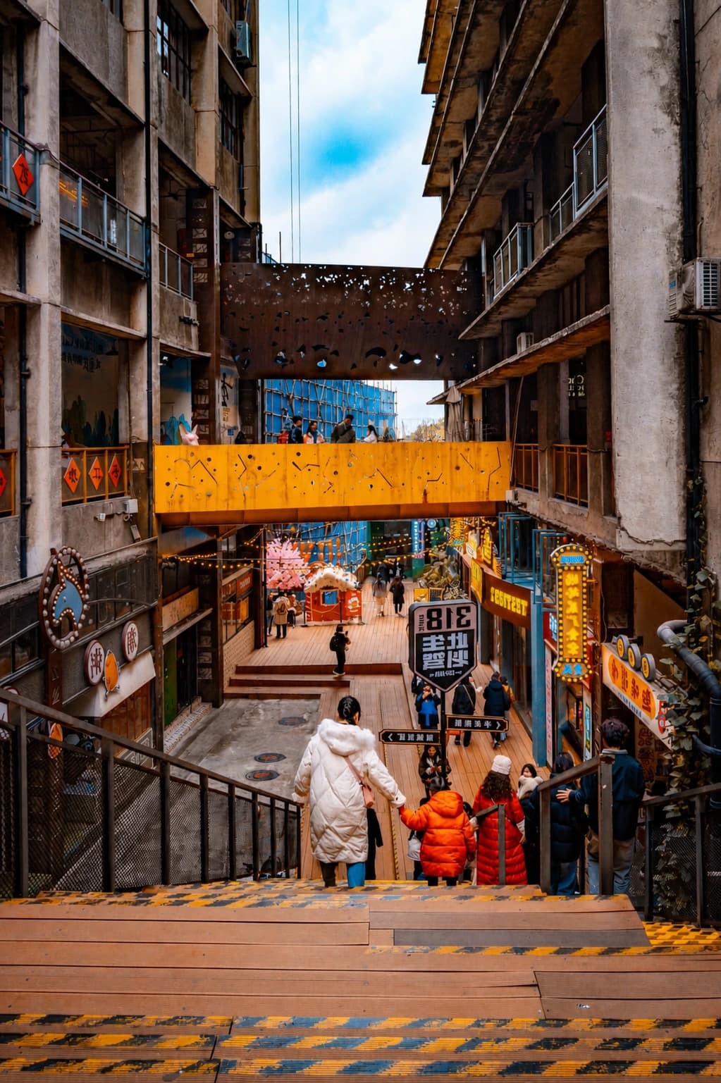
TestBed 2, also called Eling Factory or Eling Factory Creative Park (贰厂文创公园), occupies industrial buildings associated with Chongqing's former printing industry. The durable subject is the conversion itself: heavy structural bays, ramps, service passages and old work buildings adapted for studios, cafés and exhibitions. Tenants and murals change. The industrial scale remains.
Use the district for four different pictures:
- Factory establishing frame: 24–35mm, with at least two building planes and a visible route through the space.
- Ramp or stair geometry: place the diagonal across the frame instead of centring it; wait for one person to provide scale.
- Old material against a new insertion: pair concrete, brick or metal with one contemporary sign or window, without making a shop advertisement the whole image.
- Ridge opening: use a public gap between buildings to connect the industrial foreground with the city below.
The separate Eling Factory guide explains the industrial site in more detail. For this walk, limit the stop to 45–60 minutes. Leave 60–75 minutes before sunset even if the district is becoming livelier; the next streets are the part that changes most beautifully with the light.
Food, water and toilets
TestBed 2 is the best point to refill water, use a toilet or buy a simple snack before the descent. Choose from what is visibly open and check posted menus. Do not depend on a named café from an old post: businesses and opening hours are the most volatile layer of the district.
If you want a full meal, eat before beginning or after reaching Liziba. A seated meal here can consume the entire sunset transition. The route is more coherent when the factory is a visual and rest stop rather than the evening's dining destination.
Exit after TestBed 2
If rain begins, knees are uncomfortable or daylight is already fading fast, stop here. Return toward Eling Station by the checked public streets or request a car from a legal pickup point shown by your live map. Do not ask a driver to stop in a narrow lane or block the creative district entrance.
Leg 3: TestBed 2 to Third-Level Road
Checked baseline: 0.7 km / 10 minutes of movement. Allow 25–40 minutes with photographs.
This is the route's most Chongqing-like transition and the easiest place to make a navigation mistake. From the TestBed 2 pin, the checked AMap route uses:
Eling Street → a brief Health Road connection → public pedestrian links → Guihuayuan Road → Jialing New Road → Third-Level Road
Save the matching map names as Eling Street (鹅岭正街) → Health Road (健康路) → Guihuayuan Road (桂花园路) → Jialing New Road (嘉陵新路) → Third-Level Road (三层马路). The short unnamed connectors between mapped roads are why live navigation matters. Keep to signed public paths. Reject a shortcut if it enters a residential gate, service yard, construction edge or unlit stair that is not clearly part of the public route.
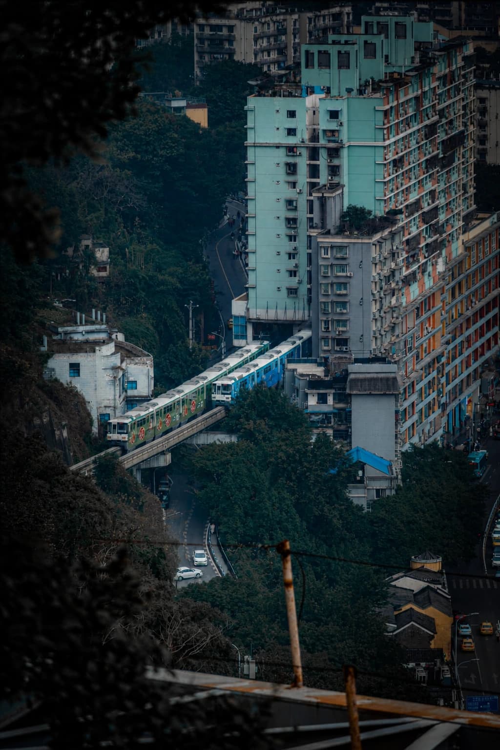
Third-Level Road is less about one monument than the relationship between levels. Roads, retaining walls, older residential fabric, rail infrastructure and vegetation occupy the same hillside. Photograph the layers rather than searching for a single “secret spot.”
Three frames for the descent
The sloping street: use 1× or 24–35mm. Stand at the side of a safe public pavement and let the road line show the grade. Include the destination of the street; a frame filled only with asphalt does not explain the city.
The compressed layers: use 2× on a phone or 50–85mm on a camera when the road, railway and buildings overlap. Longer focal lengths make distant levels appear closer. Keep one clear subject so the result does not become visual clutter.
The warm-cool transition: about 30–50 minutes before sunset, expose for the bright sky and allow shaded walls to remain dark. When the first lamps appear, make one frame with a blue or warm sky and one practical street light. There is no need to wait for every building to illuminate.
People live and work along this corridor. A doorway, laundry line or stair is not a portrait set merely because it looks atmospheric. Photograph from the public way, avoid aiming into windows, and move immediately if you are narrowing the passage.
The Fotuguan exit
At Third-Level Road, you still have a clean escape. Fotuguan Station — 佛图关地铁站 is about 0.4 km / 6 minutes away on the checked walking route. Use it when:
- the pavement is wet enough to make the final slope uncomfortable;
- your knees are tired;
- the station construction at Liziba makes a simple exit more valuable than the final picture;
- you have already photographed Liziba on another day.
This cut preserves the route's park, industrial and neighborhood layers. Missing one landmark is better than rushing an unsafe descent.
Leg 4: Third-Level Road to the Liziba platform
Checked baseline: 0.4 km / 5 minutes before crossings, crowds and level changes.
Follow Jialing New Road (嘉陵新路) northeast, then continue along Liziba Main Street (李子坝正街) to the official platform pin. The map distance is short, but the upper station entrances, lower road and viewing area occupy different levels. Use marked crossings and current directional signs.
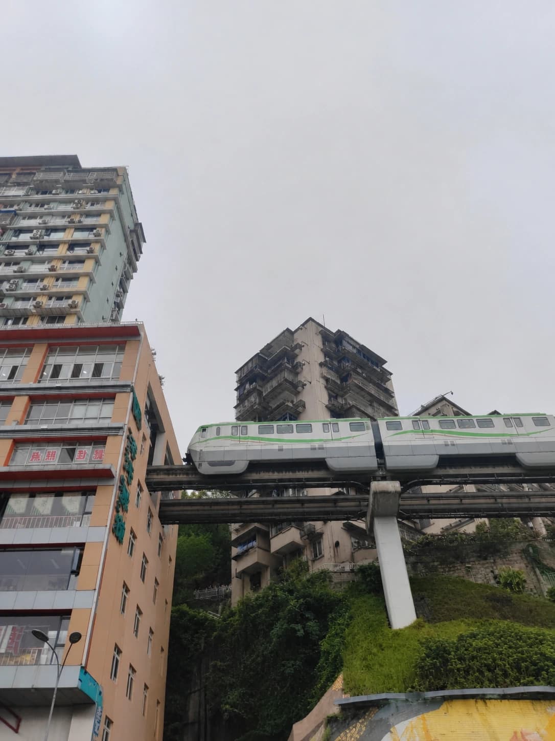
The final landmark works because the station and building share one structure. From the official public area, the train seems to disappear into the tower. Your first picture should explain that relationship clearly before you try a playful pose.
Make the complete landmark frame first
Use a phone's 1× lens or approximately 24–35mm. Include the opening, several floors of the building and enough street or platform foreground to show scale. Start a burst before the train nose appears and continue until it clears the opening.
Do not begin with 0.5× unless the crowd leaves no other option. An ultra-wide lens can make the building lean and shrink the train. Do not begin with a tight zoom either: if the building disappears, the train looks as if it is entering an ordinary tunnel.
Then try the person-and-train alignment
Keep the subject inside the pedestrian area and behind every barrier. The photographer should adjust sideways while watching the screen; the subject should make small movements in place. A raised hand, silhouette or playful “hold the train” gesture works through perspective. Nobody needs to step into the road.
Lock focus on the person and use burst mode. The photograph succeeds when the gesture is readable and the station building still has enough context to identify the place.
Finish with blue-hour context
If you arrive around sunset, wait for the sky to deepen but stop before it turns black. Make one horizontal frame that includes the building and one vertical frame that includes more of the slope. At blue hour, reduce exposure slightly to preserve lit windows and signs.
The separate Liziba guide covers the platform, ride and optional telephoto viewpoint. For this walk, the official platform is the finish. Do not climb back uphill to add another viewpoint after dark.
Current Liziba construction: follow the onsite route
The 2026 station-upgrade plan affects circulation. The published schedule includes partial station-platform works through November 30, 2026, work around Exit 1 through September 25, and Hall A closure through October 31. A later municipal update states that the public viewing platform is open, so the landmark remains a valid finish, but the route between station areas may differ from old videos.
These are planned dates, not proof that a particular passage is open at the minute you arrive. Read the newest station signs, follow staff directions and allow extra transfer time. If a barrier changes the camera line, remain in the open public viewing area instead of searching for a residential or commercial bypass. The current official construction notice is the useful source to check while the works continue.
Twelve photographs that make a complete set
You do not need to photograph every wall. Aim for a sequence in which each image has a different job:
- Eling Station exit with enough street context to establish the start.
- A garden path or railing leading through Eling Park.
- A ridge view with trees or pavilion structure in the foreground.
- A wide industrial frame at TestBed 2.
- One material detail: brick, concrete, steel or an old structural joint.
- A ramp or stair with one person for scale.
- The first clear downhill street after leaving the factory.
- A compressed frame of two or three city levels.
- A quiet neighborhood turn in late light, made from the public path.
- The complete Liziba train-through-building landmark.
- One person-and-train perspective frame, if the platform has space.
- A final blue-hour view with the building, sky and surrounding slope.
If time is tight, keep 2, 4, 7, 10 and 12. Those five images still explain the journey from ridge to river. Cut repeated portraits and minor details before cutting the complete landmark frame.
Phone settings for the whole walk
Daylight and golden hour
- Use 1× for garden, architecture and sloping streets; use 2× for compressed levels and details.
- Use 0.5× sparingly. Keep the phone level and place important faces or buildings away from the stretched corners.
- Tap the brightest important area, then lower exposure slightly. Chongqing haze can turn a pale sky white before the shaded street looks bright enough.
- Use a short burst for walking subjects and every Liziba train pass.
- Clean the lens before blue hour. Humidity and fingerprints create halos around lamps.
Blue hour and night
- Use Night mode for a static building frame, then check the result for doubled train edges.
- For the moving train, use the normal camera or shorten Night mode. A brighter file is not useful when the train becomes a translucent streak.
- Brace your elbows against your body. Do not rest the phone outside a railing or lean over traffic.
- Keep the sky dark blue. Lifting it until it looks like day removes the transition that gives the route its story.
- Avoid high digital zoom. A sharp 2× image cropped later is usually better than a soft 8× capture.
For a portrait at Liziba, make the face exposure before the sky is fully dark. A companion can hold a small continuous light close to the subject and below eye level, provided it does not distract drivers, train staff or other visitors. Direct flash flattens the face and often leaves the building black.
Camera setup without a heavy bag
A 24–70mm equivalent zoom covers the entire route. A faster prime can help after sunset, but changing lenses on a crowded platform usually loses more moments than it gains. Leave a tripod behind unless you know you need a static city frame and can keep it completely outside pedestrian circulation.
Useful starting points:
- Daylight walk: aperture priority around f/5.6–f/8, auto ISO and a minimum shutter near 1/250 second for people.
- Late street light: f/4–f/5.6, 1/125 second and auto ISO with a sensible upper limit.
- Moving train: 1/500 second when light allows; raise ISO rather than accepting motion blur by accident.
- Static blue-hour building: f/5.6, stabilize the camera safely and lower the shutter only after the moving train frame is secure.
- Highlight insurance: make one normal exposure and one around 2/3 stop darker when windows or signs clip.
Use a lens hood in rain and check the front element after every change between air conditioning and humid outdoor air. Do not chase perfect technical sharpness at the cost of blocking a public path.
Weather changes the route
Clear evening
Walk the full sequence. Give Kansheng Tower or the park edge a little more time, and use 50–85mm to compress distant city levels. Leave TestBed 2 on schedule even when the light feels generous; the descent still needs daylight.
Haze
Use near and middle layers rather than a distant panorama. In the park, photograph trees against buildings. At TestBed 2, emphasize material and shadow. On Third-Level Road, use a normal lens and include walls, railings or vegetation. The Liziba train remains readable because the subject is close.
Do not try to erase all haze in editing. It is part of Chongqing's atmospheric depth. Excessive dehaze creates halos around buildings and unnatural dark patches in the sky.
Light rain
Shorten the park, skip the tower if steps are slick and use TestBed 2's sheltered edges only where access is clearly public. Wet pavement can reflect warm lamps on the descent, but keep your attention on footing and traffic. Put the phone on a wrist strap and keep one hand free for rails.
At Liziba, shoot from the official covered or open public area available that day. Protect the lens with a hood or cloth. Do not stand at the curb for a reflection.
Heavy rain, lightning or strong wind
Do not run the route. Use Line 1 and Line 2 to visit the two ends separately only if local travel remains safe, or move the walk to another evening. A ridge tower, exposed road and crowded viewing area are poor places to wait through a storm.
Summer heat
Starting before sunset does not guarantee cool weather. Carry water, take the TestBed 2 rest, and use the Fotuguan exit if symptoms begin. The direction reduces climbing but does not remove heat, humidity or the strain of downhill braking on knees.
Public-space and photography boundaries
This guide uses public park paths, public streets, the open creative-district lanes and the official viewing platform. That boundary keeps the route durable.
- A café purchase does not guarantee a window, terrace or portrait position.
- A hotel floor, residential stair, apartment corridor or rooftop is not public because a photograph from it appears online.
- Museum admission does not automatically allow tripods, flash, staged portraits or commercial shoots.
- Do not move barriers, enter a construction zone or use a closed stair to preserve an old route.
- Keep bags, tripods and subjects to the side of stairs and narrow streets.
- Ask before making a close portrait of a resident, worker, guard or vendor.
- Do not aim into homes or treat laundry, doorways and children as street-scene props.
- At Liziba, remain behind the barrier. Never stand in traffic or use a laser to interact with a train.
- Drone rules and airspace conditions require separate live checks; this dense transit corridor is not a casual launch site.
If staff close one position, accept the change and use the next public frame. The route contains enough visual variety that no single angle is worth an argument or an access violation.
How to fit the walk into a Chongqing trip
Use the main Chongqing city guide to plan your base, fixed tickets and larger districts. This route is strongest as an independent late-afternoon block, not as an add-on after a full day of stairs in the lower Yuzhong peninsula.
If you have three days, the three-day Chongqing itinerary already groups west-central attractions. Replace its separate Eling and Liziba stops with this one-way walk only when the light and your energy support it. Do not duplicate both versions in the same day.
For a different evening story, the South Bank photo route moves from old hillside streets to large river views. The Eling route is tighter and more residential; the South Bank route is longer and more skyline-driven. The cyberpunk photo guide is better when illuminated infrastructure, bridges and dense night scenes matter more than the walk itself. Choose the Chongqing 8D transport route instead when riding several systems is the purpose of the day.
Final route checklist
- Check the exact local sunset, rain, visibility and heat for your date.
- Start at Eling Station Exit 1 about 2.5–3 hours before sunset.
- Save all six Chinese map pins offline or in your map history.
- Wear shoes with grip and carry water; “downhill” does not mean step-free.
- Limit Eling Park to 30–60 minutes and TestBed 2 to 45–60 minutes.
- Leave TestBed 2 at least 60–75 minutes before sunset.
- Follow the public route through Eling Street, Health Road, Guihuayuan Road and Jialing New Road.
- Use Fotuguan Station as the early exit when weather or knees deteriorate.
- Reach the official Liziba platform for sunset or early blue hour.
- Make the complete train-and-building frame before any playful pose.
- Follow current construction signs rather than an old video.
- Finish on Line 2 instead of climbing back to Eling.
The route works because the subjects change as the light changes. Eling explains the height, TestBed 2 supplies structure, Third-Level Road reveals the lived hillside, and Liziba turns the city's transport geometry into one clear moving image. Keep that progression, and a 2.1 km walk will feel like a coherent Chongqing story rather than four disconnected check-ins.