Beijing citywalk chooser: hutongs, Central Axis or modern streets
The phrase “Beijing citywalk” can describe four very different days. One route threads through lived-in hutongs and ends beside a lake. Another follows the capital's monumental north–south line for five or ten kilometres. A third moves through Sanlitun's residential edges, art spaces and retail lanes. A fourth joins early twentieth-century civic facades to a restored watercourse and the old commercial streets near Qianmen.
They are not interchangeable. The wrong choice can leave you carrying a camera through midday heat, reaching a controlled site without a reservation, or spending half a day in shopping streets when you wanted grey roofs and temple courtyards. This page makes the choice first. The detailed Beijing hutong route guide and Beijing Central Axis route then handle the two old-city branches stop by stop.
If you want one answer immediately:
- Choose a hutong family for human-scale lanes, rooflines, temples or neighbourhood food.
- Choose the Central Axis for Beijing's clearest monumental story and the Jingshan panorama.
- Choose Sanlitun for contemporary architecture, browsing, food and an easy late-afternoon-to-evening walk.
- Choose Dongjiaominxiang to Yangmeizhu Xiejie for architectural variety without the reservations or distance of a full Axis day.
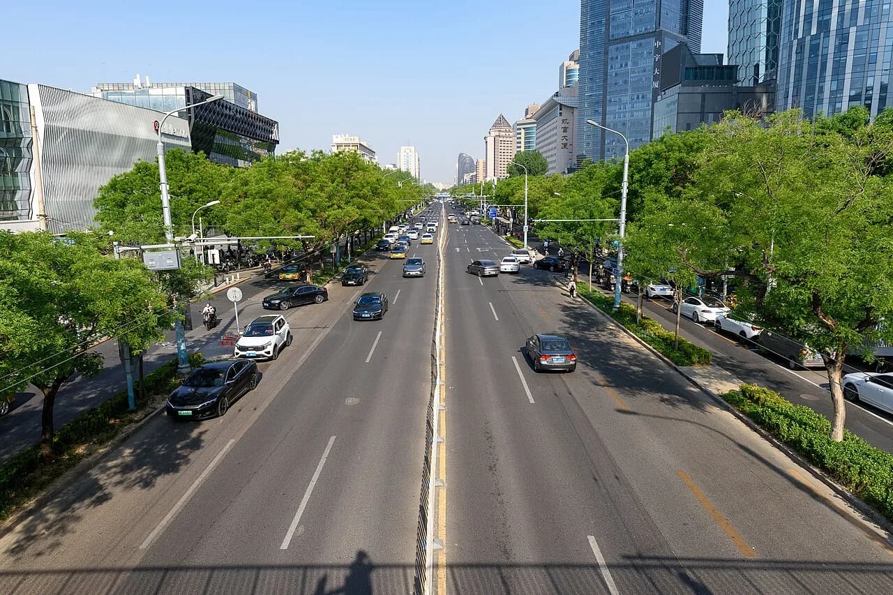
The broad road, mature trees and layered commercial skyline above show the modern-streets result. Sanlitun is not a substitute for old Beijing; it is the right choice when you want to see how the city shops, eats and presents contemporary architecture now.
Photograph by N509FZ, adapted from Wikimedia Commons under CC BY-SA 4.0.
Compare the four walks in one table
Distances are direct walking between the named anchors. Your phone will record more after courtyards, lake edges, security approaches, shopping loops and photo detours.
| Route | Base walk and real time | Slope and surface | Reservation burden | Strongest photo result | Food and shopping | Best exits |
|---|---|---|---|---|---|---|
| Old-city hutong families | About 0.7–2.0 km between main anchors for most branches; 2.5–5 hours | Mostly level lanes; uneven paving, thresholds and optional tower steps | None for public lanes; separate rules for temples and museums | Grey roofs, towers, lakes, temple details, dagoba glimpses, daily street texture | Low to high depending on branch | Shichahai, Yonghegong/Andingmen, Fuchengmen or Caishikou-area transit |
| Central Axis | 5 km highlights or 9–10 km full route; 5–10 hours | Mostly level city walking plus Jingshan's steep climb and optional tower stairs | Highest: Tiananmen, Forbidden City and some interiors require separate planning | Symmetry, gates, palace roofs and the long urban line | Low in the controlled centre, high around Qianmen | Shichahai, Qianmen, Zhushikou, Tianqiao or Yongdingmenwai |
| Modern Sanlitun | 2.7 km core or 4.2 km from Dongzhimen; 3–5 hours | Almost level; broad roads, crossings and optional indoor levels | None for the public-street route; individual venues control entry | Contemporary facades, street colour, retail lanes and evening lights | Highest | Agricultural Exhibition Center, Tuanjiehu or Workers' Stadium stations |
| Civic facades to Qianmen lanes | 2.8 km main anchors, about 3.8 km with the Hufangqiao exit; 3–4 hours | Level streets and narrow park paths; slippery stone near water in rain | Low for exterior/public-space route | Formal facades, water reflections, renewed blocks and angled lanes | Medium, rising near Beijing Fun and Yangmeizhu | Qianmen or Hufangqiao |
The simple decision is about friction. The Axis gives the largest historical payoff and asks for the most planning. Sanlitun asks for the least advance work and gives the most commercial choice. Hutongs feel most intimate and therefore demand the most care around residents. The civic route sits between them: visually varied, manageable in half a day and mostly independent of ticketing.
Choose old-city hutongs when street scale matters most
“Walk the hutongs” is still too broad a plan. The useful choice is which family of streets fits your interest:
- Bell and Drum Towers to Shichahai: the safest first-visit choice. Allow 2.5–4 hours. It gives tiled roofs, two tower silhouettes, Yandai Xiejie and a lake finish without requiring a long distance.
- Lama Temple to Guozijian and Wudaoying: choose this for religious practice, painted timber and educational history. The anchors are close, but interiors make it a 3–5 hour route. Check current temple and museum access rather than assuming every gate is open.
- White Dagoba and west-city history: choose this for a quieter 2.5–4 hour walk, stupa views above roofs and small museum stops. It works best when you are prepared to protect interior closing times.
- Niujie, Fayuan Temple and nearby lanes: choose this when a meal and community history matter more than architectural spectacle. Allow 3–5 hours because food queues and respectful temple or mosque visits take time.
The separate civic/architecture branch appears later on this page because it competes directly with the Axis and Sanlitun for photographers. The full hutong chooser provides exact map pins, opening decisions and route etiquette for all five families.
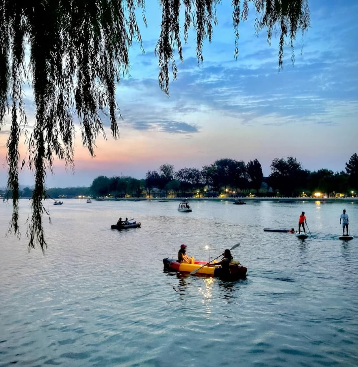
This blue-hour lake scene is a realistic finish for the north hutong branch. It is not the expected result from a temple morning, a Niujie food walk or a Sanlitun evening. Choose the photographic ending before choosing the route.
Hutong strengths and limits
Hutongs give the best sense of changing scale. A tower appears at the end of a narrow lane, a white stupa rises behind ordinary roofs, or a bicycle and delivery cart explain how the street functions. They also have the weakest separation between sightseeing space and private life. An open gate is not an invitation. A doorstep is not a bench. Laundry, family conversations and parked bicycles do not become props because the lane is photogenic.
Most routes are broadly level, but “flat” does not mean barrier-free. Expect broken edges, parked vehicles, narrow passages and occasional steps. Tower interiors and some temple thresholds add steeper obstacles. For a stroller, wheelchair or tired knees, select a lakeside or wider-street version and accept that the exact historical lane may require a detour.
In rain, a short temple branch can work if interiors remain open; lakeside stone and polished paving need caution. In summer heat, choose an early start and one compact family. In winter, the low sun can be excellent, but exposed lakeside wind makes Shichahai colder than the map suggests.
Choose the Central Axis for one coherent monumental story
The Central Axis is the only route here that can organize a full day around one historical idea. Towers, Wanning Bridge, Jingshan, palace walls, civic space, Zhengyangmen, Qianmen and Yongdingmen align into a sequence that explains how the capital was ordered. The reward is clarity. The cost is distance, security and reservation friction.
There are three sensible versions:
- The 5 km highlights route runs from the Bell and Drum Towers through Wanning Bridge and Jingshan, around the Forbidden City's east side, then toward Tiananmen Square and Zhengyangmen. Allow 5–7 hours.
- The 9–10 km full ground route continues through Qianmen, Tianqiao and Yongdingmen. Allow 7–10 hours and keep interiors selective.
- The reserved palace route starts south and follows the Forbidden City's required south-to-north visitor flow before Jingshan and the northern axis. Use it only when you already hold the palace ticket and understand the entry document rules.
Tiananmen Square remains a controlled civic site. Follow the current official reservation channels, carry the original passport used for the booking and leave time for security. Do not assume one attraction confirmation opens every checkpoint. The detailed Axis guide tracks the separate decisions for the Square, Forbidden City, Jingshan, towers and Zhengyangmen.
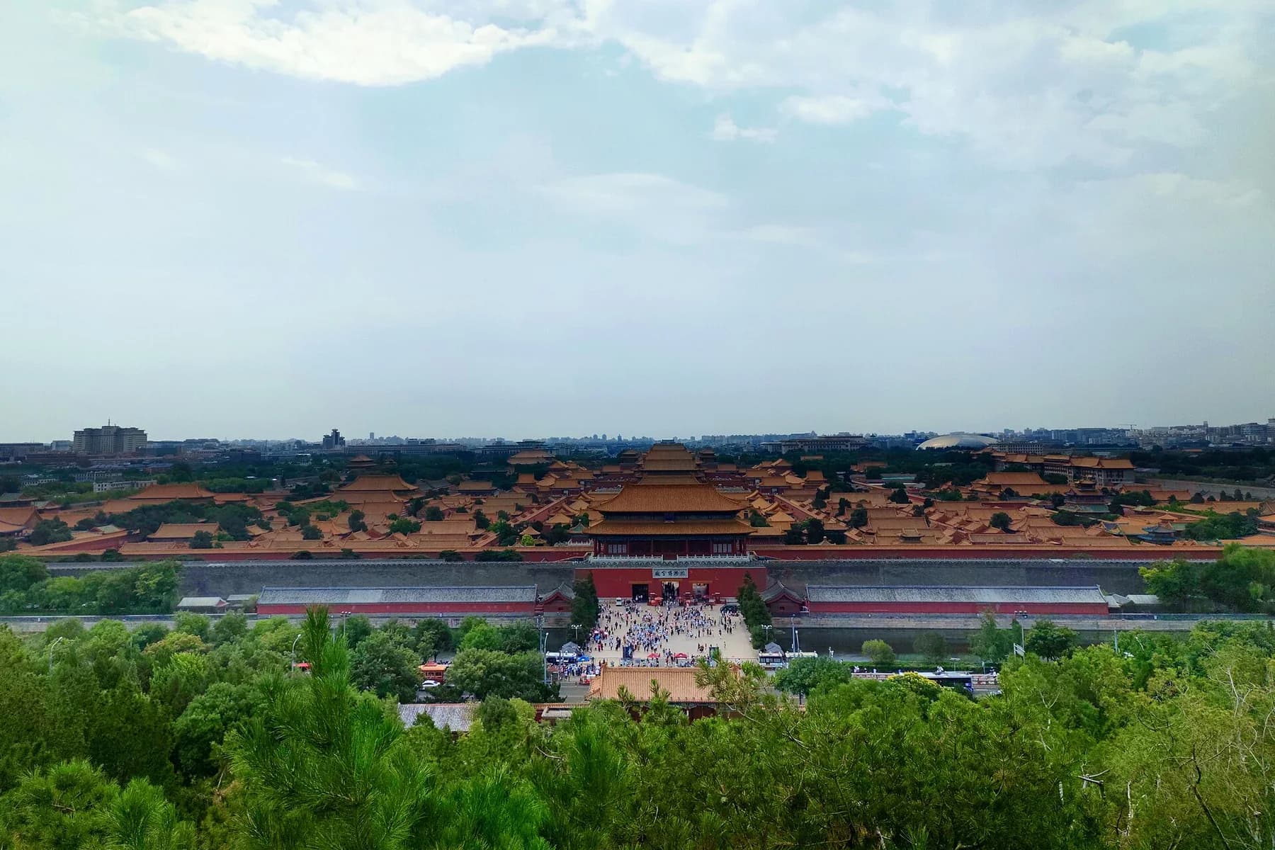
This Jingshan view is why many photographers accept the climb and crowds. It compresses palace roofs and gates into one line. Haze, temporary controls and the number of people at Wanchun Pavilion still affect the result.
Photograph by CNHowey, adapted from Wikimedia Commons under CC BY-SA 4.0.
When the Axis is the wrong choice
Skip it on a day when you have only two or three free hours, have not secured the access you consider essential, or need frequent indoor breaks. Much of the central and southern line is exposed to sun, wind and rain. Food becomes easiest around Qianmen, which arrives late in the highlights sequence. A traveller who mainly wants shops, cafes and night energy will spend too long reaching them.
The route is also a poor spontaneous backup for a sold-out Forbidden City day if your real goal remains the palace interior. The public-space version is valuable on its own, but it produces moat geometry, gates and city alignment rather than an improvised palace visit. Read the exact Central Axis route and exits before committing.
Choose Sanlitun for modern streets, browsing and an evening finish
The verified modern route is:
Dongzhimen Station → Xingfucun Middle Road → A.C. Art Museum → Sanlitun West Fifth Street No. 5 Courtyard → Taikoo Li North → 3·3 Building → Taikoo Li South → Workers' Stadium Station.
Walk the full 4.2 km version from Dongzhimen for a gradual transition from transport hub and diplomatic-residential edge into the retail district. For the 2.7 km core, arrive by taxi or ride-hail at Xingfucun Middle Road and start there. The checked core legs total about 40 minutes of movement; allow 3–5 hours for browsing, food, crossings and photography.
This route intentionally avoids a long shop checklist. Shops change, and Taikoo Li's operator documents major tenant and public-space changes across its North zone in 2025–26. The durable experience is the shift between street types and building scales.
1. Use Dongzhimen only when the approach is part of the walk
Open the Dongzhimen Station map pin. The checked walk to Xingfucun Middle Road (幸福村中路) is about 1.5 km / 21 minutes.
This approach is useful for reading the area, not for collecting attractions. Keep to legal crossings and photograph broad street context rather than guard posts, controlled entrances or people entering residential compounds. If time is limited, skip the approach and begin at Xingfucun. The route loses distance, not its main visual story.
2. Let Xingfucun and the art stop establish a smaller scale
From Xingfucun Middle Road, the verified walk to A.C. Art Museum (奥加美术馆) is about 1.0 km / 14 minutes. Treat the museum as a route anchor, not a guaranteed exhibition. It is connected to a hotel/art complex, and current programming, private events or staff instructions can change access. The route works from public streets and permitted common areas even if the interior is unavailable.
Continue about 0.7 km / 10 minutes to Sanlitun West Fifth Street No. 5 Courtyard (三里屯西五街五号院). Here the useful subject is the relationship between courtyard-scale buildings, trees, signs and the street. Check any doorway before entering. Some spaces that look like public galleries or shops may be offices, event venues or private businesses.
If the weather turns or your energy drops, walk about 0.9 km / 13 minutes east to Agricultural Exhibition Center Station. This is the cleanest northern exit.
3. Move through Taikoo Li North before the denser south zone
The checked leg to Taikoo Li Sanlitun North (三里屯太古里北区) is about 0.6 km / 8 minutes. Swire describes the larger development as a low-density, open-lane complex. Its 2026 update also documents a major North-zone transformation and new flagship architecture, which is why an old “must-visit stores” list is less reliable than a route based on spaces.
Use the lanes to compare separate building volumes, setbacks, bridges and the way retail frontages create small plazas. Beijing's official visitor information lists the Taikoo Li destination as open all day, but that does not mean every shop, restaurant, terrace or interior is open. Check the current tenant page or the door for individual hours.
Commercial-property rules apply. A phone snapshot from an open lane is different from a tripod, flash, costume change or directed fashion shoot. Posted signs and staff instructions control. Do not block a store entrance, photograph closely into a window after being asked to stop, or assume that a terrace is public because a viral post once used it.
4. Finish through 3·3 and Taikoo Li South
3·3 Building (3·3大厦) sits about 0.1 km / 2 minutes from the North-zone anchor in AMap's walking plan. Use it as a contrast in retail scale and tenant mix; do not plan the day around one saved shop without checking that it still exists.
Continue about 0.1 km / 2 minutes to Taikoo Li Sanlitun South (三里屯太古里南区). The map distances between these large complexes look almost trivial because their POI entrances are close. Browsing inside them can add several kilometres. Decide on a time cap before entering the first store.
Late afternoon gives readable facades; blue hour adds signs and reflected colour without making the sky fully black. For dinner, choose from what is visibly open and priced that day. Sanlitun has the highest food density of the four walks, so there is little value in queueing for one social-media shop when alternatives surround you.
Finish at Workers' Stadium Station (工人体育场地铁站), about 0.2 km / 4 minutes from the mapped South-zone anchor. Tuanjiehu Station is another checked exit, about 0.4 km / 5 minutes away. On an event night, crowd controls around Workers' Stadium can change the most convenient entrance; follow live signs rather than forcing the saved pin.
Sanlitun weather and access profile
This is the best of the four choices for uncertain weather because shops, restaurants and metro exits create frequent shelter. It is still an open-lane district: rain and wind remain real between buildings, and umbrellas make busy crossings harder. In midsummer, begin after the strongest heat and let the walk turn into dinner. In winter, start earlier so the smaller northern streets retain daylight, then use the brighter retail blocks after dark.
The route is almost level. The main access problems are crossings, curbs, crowds and optional stairs inside commercial buildings. Lifts may exist inside a complex without making every desired shortcut step-free. Keep an accessible route on the signed public circulation path and ask staff when a bridge or internal stair interrupts it.
Choose civic facades and Qianmen lanes for architectural variety
This branch uses the already verified sequence:
Dongjiaominxiang (东交民巷) → Xixinglong Street (西兴隆街) → Sanlihe Park (三里河公园) → Beijing Fun (北京坊) → Yangmeizhu Xiejie (杨梅竹斜街).
The main anchors total about 2.8 km / 39 minutes of direct walking. Allow 3–4 hours because the value lies in facade comparisons, the restored watercourse and the change from formal civic scale to commercial and publishing-era lanes.
Choose this over the Axis when you want architecture but have no interest in a long ceremonial line or controlled-square entry. Choose it over hutongs when exterior facades and urban change matter more than temple life or residential texture. Choose it over Sanlitun when you want independent street history with only a moderate amount of shopping.
Dongjiaominxiang requires restraint. Many institutions are exterior views, and some entrances are guarded or controlled. Photograph a facade in its street context from ordinary public pavement. Do not aim a long lens at a guard post, argue about a temporary barrier or let a saved photo override current police instructions.
Sanlihe Park is the intimate midpoint: water, small bridges and low buildings compress the scene. Keep portrait sessions short so other people can cross. Beijing Fun then widens the public space before Yangmeizhu returns to a narrower street. Old posts often promote one bookstore window, cafe terrace or shop doorway; access and purchase conditions belong to the business, not to the route.
Exit at Qianmen if weather or fatigue removes the value of the last lane. After Yangmeizhu, the checked walk to Hufangqiao Station is about 1.0 km / 13 minutes. The detailed hutong route page explains this architecture branch stop by stop.
Decide by the time you actually have
Two hours
Do not start the Axis. Choose a shortened north-hutong loop, or go directly to Taikoo Li North and South with a fixed browsing limit. Two hours can produce one coherent set of photographs; it cannot absorb security, a hill climb and five kilometres of old-city pavement.
Half a day
All hutong families, the 3.2 km Sanlitun core and the civic-facade route fit. Pick one. A half-day becomes rushed when you connect the Bell Tower, Lama Temple, Qianmen and Sanlitun simply because each looks close on a city map.
Five to seven hours
Choose the 5 km Axis highlights route, a deep temple-and-hutong day, or the full Sanlitun route with a long meal. The Axis needs the earliest commitment because reservations and daylight control it. Sanlitun can start later and remain useful after dark.
A full day with strong walking fitness
The 9–10 km Axis is the clear full-day project. Another valid choice is one hutong family in the morning and Sanlitun after a real transit-and-rest break. Avoid joining two old-city walks without a break; the repeated lanes reduce attention before they add understanding.
Decide by weather and season
- Hot, sunny day: choose Sanlitun or one compact hutong family. The Axis has the longest exposed sections; if it is essential, split it into two half-days.
- Light rain: Sanlitun offers the most shelter. The civic route can be atmospheric, but stone near Sanlihe becomes slick. Protect the lens and keep away from narrow bridge bottlenecks.
- Heavy rain or storm warnings: replace the citywalk with a museum or other indoor plan. Retail cover does not make outdoor crossings storm-proof.
- Cold, clear winter day: the Axis benefits from crisp visibility, but wind exposure is serious. A west-city hutong route can give low-sun pagoda views with shorter outdoor legs.
- Autumn colour: the civic route and Sanlitun's tree-lined streets both work. Do not chase a single dated foliage post; leaf timing shifts each year.
- Haze or poor visibility: choose hutong detail, temple colour or Sanlitun geometry. Jingshan's long view loses the feature that justifies the climb. Use current air-quality and weather information on the day.
Choose the photographs before choosing the walk
The four routes reward different pictures. A useful shot list describes outcomes rather than exact tripod marks:
- A Drum or Bell Tower held at the end of a narrow north-city lane.
- Grey roofs, boats and a remaining band of blue sky at Houhai.
- Painted brackets and red walls with enough street context to show a working temple approach.
- The White Dagoba appearing above ordinary west-city roofs.
- The Forbidden City compressed into the Central Axis from Jingshan.
- Wanning Bridge or a gate used to reveal the north–south alignment.
- Palace-wall colour and moat reflections from a legal public path.
- Zhengyangmen or Yongdingmen framed symmetrically without standing in traffic.
- Xingfucun's smaller street fronts before the retail district expands.
- Courtyard-scale buildings and tree cover around West Fifth Street.
- Separate Taikoo Li building volumes layered across an open lane.
- Sanlitun signs and glass reflections while the dusk sky still has colour.
- A Dongjiaominxiang facade with pavement and setback explaining its civic scale.
- Sanlihe's water and bridge as a transition into low old-city buildings.
- Yangmeizhu's angled street line leading toward Qianmen's commercial edge.
For a phone, use 1× for street context and 2× for tower, roof or facade compression. Avoid 0.5× close to doorways and people; it bends verticals and exaggerates bodies at the edge. Tap a midtone facade and lower exposure slightly when signs or a bright sky clip. At blue hour, brace the phone against your own body and take a short burst rather than placing a tripod in a lane.
For a camera, a 24–70 mm equivalent covers almost everything. The Axis rewards the longer end from Jingshan; hutongs and Sanlitun need the wider end while keeping verticals controlled. A large telephoto attracts the wrong kind of attention near guarded sites and encourages invasive pictures into homes. Leave it packed unless a clearly permitted public viewpoint gives it a specific job.
Boundaries that change by route
Public pavement does not make every subject unrestricted.
- In residential hutongs: do not photograph through windows or gates, pose on thresholds, move household objects or block a resident's route. Ask before making a close, identifiable portrait.
- At temples and religious spaces: worship takes priority. Follow current rules on interiors, incense areas and ceremonies. A paid ticket does not grant a portrait release.
- Around Dongjiaominxiang and diplomatic edges: obey signs, barriers, police and security staff. Keep cameras away from guarded entrances and identification checks.
- At Tiananmen and along controlled parts of the Axis: security instructions override the itinerary. Carry the correct document and keep equipment compact.
- Inside Taikoo Li or other commercial property: management can set photography rules. Phone snapshots, professional equipment and a directed commercial shoot are different activities. Stop or move when staff ask.
- Everywhere: delivery workers, cleaners, vendors and commuters are people doing their jobs. Build the frame around architecture or street rhythm unless a person has agreed to be the subject.
Can two walks share one day?
The best pairing is a compact north-hutong morning plus Sanlitun in late afternoon, with metro travel, lunch and a real rest between them. The visual shift is large enough to justify the second walk, and Sanlitun remains active after old-city interiors close.
The civic route can finish near Qianmen lights, so it does not need an Axis extension. It already overlaps the southern old-city atmosphere. Likewise, a full Central Axis day should stand alone. Adding Sanlitun after ten kilometres usually turns the modern district into an exhausted dinner search rather than a walk.
If Beijing is only one part of a wider trip, use the three-day Beijing itinerary to protect the essential imperial sights. The four-day itinerary creates enough space for a distinct hutong, civic or modern-streets half-day. The main Beijing travel guide should control fixed-date reservations before any flexible citywalk fills the remaining time.
A final route-selection workflow
- Write down the one photograph or experience you would regret missing.
- Check whether it requires a reservation, ticket or interior opening.
- Choose the shortest route that includes it and still has a clean metro exit.
- Compare the exposed distance with that day's heat, rain, wind and visibility.
- Save the Chinese names and exact AMap pins, then download an offline map area if your connection may be unreliable.
- Set one decision time during the walk: continue, take the nearest exit or stop for food.
- Keep private homes, religious practice, guarded sites and commercial-property rules outside the demands of the photograph.
Beijing rewards walking because its city forms change so sharply. The useful goal is not to cover every saved pin. It is to choose the route whose scale, friction and visual ending match the day you actually have.